MITADER
Ministério da Terra,
Ambiente
e Desenvolvimento Rural
logologomangalvista do mar e barcos de pescapessoas a apanhar ameijoas na praiacoralvista da baiamergulhador debaixo de água a recolher dados

Centro de Desenvolvimento Sustentável para as Zonas Costeiras


Bem Vindo 
Zona Costeira 
Gestão dos Recifes 
Actividades 
Campanhas 
Conferências 
Investigação 
Publicações 
Cursos em Gestão Costeira 
Referências 
Base de Dados 
Sobre Nós 
EAME - Ecoregião Marinha da África Oriental 

separator
Aprendizagem Sobre Mangais
Estudos
Avaliação Económica do Ecossistema dos Mangais no Estuário do Limpopo
Aprendizagem Sobre Mangais

Mapping of Healthy and Degraded Mangrove Vegetation in the Limpopo Basin Estuary


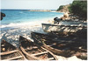
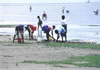
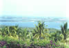
The overall objective is to map the mangrove vegetation communities and degraded
areas in the Limpopo basin estuary to inform the conservation measures and form a
basis to guide formulation of interventions under component II of the RESILIM Program,
developing an adaptive management and responses to threats.
The goal of this work is to provide a cartographic database of mangrove cover and
surrounding land cover and land use setting; provide historical and current information
about mangrove cover change and formulate a proposal for restoration area

Mangrove forest in the Limpopo basin estuary is one of the most important livelihood
resources for the Zonguene community. This resource occurs along the river banks and mud flats and provides an important breeding ground for fish and other marine
resources important for local community as source of firewood and building material.

Mangroves are under constant flux due to both natural (e.g. erosion, aggradations) and anthropogenic factors. In the last three decades, forest losses because of
anthropogenic factors have increased significantly (Giri et. al. 2010). The remaining
mangrove forests are under immense pressure from clear-cutting, land-use change,
hydrological alterations, chemical spill and climate change (Blasco et al., 2001).

The 2000 floods that hit Zonguene Administrative Post had a great negative impact in
particular the destruction of vast areas of mangrove forest in Limpopo estuary,
consequently affecting the local fisheries. During the vulnerability assessment exercise carried out in this community, it was also pointed that extensive patches of the mangrove have been destroyed by the 2000 floods and very poor regeneration is being observed. These observations are supported by a recent study by Jose (2009), who suggests as possible causes the changing in the structure and composition of the substrate and hydrological conditions.

Remote sensing and GIS are increasingly used in mangrove forestry change tracking
worldwide to assist in gathering and analysing images acquired from aircrafts, satellites and even balloons (Aschbacher et al., 1995). The increasing use of remote sensing techniques in mangrove forest mapping is due to its higher reflectance values from forested areas in the near‐infrared, moderate reflectance in the middle‐infrared and low reflectance in the red spectral bands (Trisurat et al., 2000). Higher spatial resolution imageries (0.60 m) and its annual temporal resolution are great valuable resources for mapping mangrove natural resources and track their changes along different communities and times (Da Silva, 2005). The notable advantages of using GIS include the ability to update the information rapidly, to undertake comparative analytical work and making this information available as required (Silapathong and Blasco, 1992).

This study aims to map the mangrove degraded areas in Limpopo estuary to inform the conservation measures and form a basis to guide formulation of interventions under component II of the RESILIM Program, developing an adaptive management and responses to threats. Results generated from this study could provide an additional opportunity for a better understanding of mangrove forests geared towards their sustainable management.


Mapping of mangrove vegetation Communities and degraded areas in The limpopo basin estuary -

Mapping of mangrove vegetation Communities and degraded areas in
The limpopo basin estuary


Veja também:
Avaliação Económica do Ecossistema dos Mangais no Estuário do Limpopo

Avaliação económica do ecossistema dos mangais no estuário do Limpopo-2014


breves
Nenhuma notícia nesta categoria, de momento...

©2005+ Centro de Desenvolvimento Sustentável para as Zonas Costeiras. Esta página tem o apoio financeiro da DANIDA.
Sítio realizado com SPIPTermos e Condições